


Norgeskart Outdoors
Beschreibung von Norgeskart Outdoors
Norgeskart Outdoors bietet alles, was Sie für Ihre Outdoor-Aktivitäten benötigen. Sei es Jagen und Angeln, Wandern, Radfahren, Skifahren oder Bootfahren. Alle Funktionen und Inhalte können auch ohne Mobilfunkempfang zur Verfügung gestellt werden.
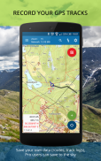
- Registrieren, messen und kategorisieren -
Registrieren Sie Sonderziele, Routen, Gebiete und zeichnen Sie Tracks auf. Organisieren Sie die Daten, indem Sie Ihre eigenen Kategorien mit Farben und Stilen/Symbolen für jede Kategorie erstellen. Auf Wunsch können Ihre Daten in/aus GPX-Dateien geschrieben und gelesen oder geräteübergreifend und mit dem Kartenportal norgeskart.avinet.no synchronisiert werden. Sie können Dateien auch ganz einfach über die Datenlisten in der App mit anderen teilen.
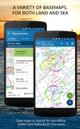
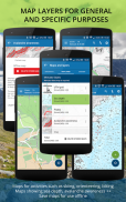
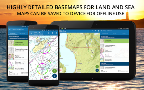
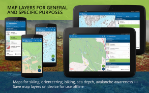
- Tolle Outdoor-Karten und Kartenebenen -
Wählen Sie aus mehr als 40 Karten und Kartenebenen. Schöne Karten von Norwegen von den norwegischen Kartierungsbehörden können vor Ihrer Reise zur Offline-Nutzung heruntergeladen werden. In vielen Apps können Sie jeweils nur eine Ebene aktivieren. Hier können Sie beliebig viele Ebenen kombinieren, um einen vollständigen Überblick über Ihre Umgebung zu erhalten. Z.B. durch Abbiegen auf Pisten, Lawinensteilheit und schwache Eisschichten.
Norgeskart Outdoors unterscheidet sich von den meisten anderen Karten-Apps dadurch, dass es sowohl Mercator- als auch UTM-projizierte Karten unterstützt. Dadurch konnten die hochauflösenden UTM-Versionen der topografischen Karten der norwegischen Kartierungsbehörde angezeigt werden. Die UTM-Dienste verfügen im Vergleich zur Mercator-Version über zwei zusätzliche Detailebenen.
- Eigene Karte und Kartenebenen -
Fehlt Ihnen eine Karte oder Kartenebene? Die App unterstützt jetzt das Hinzufügen eigener Karten und Ebenen von WMS-, WMTS-, XYZ- und TMS-Diensten. Eine großartige Quelle für zusätzliche Karten und Ebenen in Norwegen ist die Website geonorge.no. Sie können auch versuchen, Karten aus anderen Ländern hinzuzufügen, die App unterstützt jedoch nur Mercator- und UTM33-Projektionen.
- TellTur -
Planen Sie Ihre nächste Reise mit Reisevorschlägen und Beschreibungen von telltur.no. Mit TellTur können Sie sich über die App bei Ihrer Ankunft an einem Tourziel registrieren und mit anderen um den Besuch der meisten Orte konkurrieren.
Diese App enthält sowohl kostenlose als auch kostenpflichtige Inhalte (siehe vollständige Übersicht unten). Mit der Bezahlung eines Abonnements unterstützen Sie die Weiterentwicklung der App und nutzen alle spannenden Angebote, die wir zu bieten haben.
Kostenlose Inhalte:
-------------------
- Topografische und nautische Mercator-Karten für Norwegen, Spitzbergen und Jan Mayen
- Open-Air-Strecken im Sommer und Winter
- Steilheit mit Auslauf
- Ortsnamen und Höhe/Tiefe für die Cursorposition anzeigen
- Suchen Sie nach Ortsnamen, Adressen oder Koordinaten
- Import und Export von GPX-Dateien
- Verfolgen Sie die Aufzeichnung mit Diagrammen und Details
- Erstellen Sie Routen und POIs
- Kompass
- Grundstücksgrenzen
Pro-Abonnement:
-------------------
- Laden Sie norwegische Karten zur Offline-Nutzung herunter
- Extra detaillierte UTM-Versionen topografischer Karten
- Bereiche erstellen und vermessen
- Erstellen Sie eigene Kategorien
- Topokarte von Schweden (offline, aber ohne Downloadbereich-Funktion)
- Laden Sie POIs, Tracks und Routen hoch
- Synchronisieren Sie Ihre Daten geräteübergreifend und mit dem Kartenportal
- Erweiterte Eigenschaftenebene (Kataster)
- Wirtschaftskarte (N5-Raster).
- Historische Karte
- Wanderwege
- Mountainbike-Routen
- Pisten für Alpin und Langlauf
- Lawinenbewusstsein und Vorfälle
- Schwaches Eis
- Schneehöhe und Skibedingungen
- Schneemobilspuren
- Meerestiefen und Seetiefen
- Ankerplätze
- Naturschutzgebiete
- Ton und Radon
Pro+-Abonnement (199 NOK pro Jahr):
-------------------
- Alles in Pro
- Orthofotokarten für Norwegen und Spitzbergen
- Fügen Sie Ihre eigenen Karten und Ebenen hinzu
- Grundgesteinskartenebene
- Regelmäßige Aktualisierung von Punkten aus Online-KML-Dateien. Getestet mit TeleSpor.
Norgeskart Outdoors – Version 3.27.6
(14-03-2025)Norgeskart Outdoors – APK Informationen
APK Version: 3.27.6Paket: no.avinet.norgeskartNeueste Version von Norgeskart Outdoors
Weitere Versionen


 3.64
3.64
Apps in derselben Kategorie

Das könnte dir auch gefallen...


